Community Corner
Block-by-Block Lawrenceville: Where are the Creative People, Carpoolers and Veterans in Town?
Taking brush strokes of data to create a picture of town.

Newscruncher is a daily series that breaks down the characteristics of your town by the numbers. You can see more posts by clicking the Newscruncher link above the headline or by checking out our weekend roundups.
Map: What Section of Town Has the Most Carpoolers?
The map is a snapshot of what section of town has the most carpoolers.
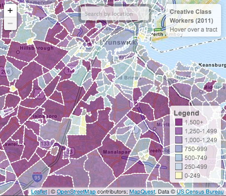
What Section of Town Does the Creative Class Live In?
A snapshot of where the "creative class" in town works across your neighborhood, as reported by the 2011 American Community Survey.
Map: Where Do the Divorced Women Live in Town?
The map shows the number of divorced women across your neighborhood as reported by the 2011 American Community Survey.
Map: Who in Town Works From Home?
The map shows which areas have the most people working from home.
Map: What Part of Town Has the Most Veterans?
The map below shows the percentage of the civilian population 18 years and older who are veterans of the U.S. Military
If you see any technical issues with this map, or if you'd like to suggest ideas for future Newscruncher articles, please email data@patch.com.
Get more local news delivered straight to your inbox. Sign up for free Patch newsletters and alerts.